
The catastrophic flash floods that struck the Nepal–Tibet border region on 26 August 2026 have once again exposed the growing danger of cascading disasters in the Himalayas. What began high in the mountains as a collapse of ice, rock and debris rapidly turned into a destructive surge that swept through narrow valleys, damaged settlements and cut vital transport, communication and power links.
The scale of the tragedy is still emerging. Hundreds of people have died, thousands remain unaccounted for and more than 90,000 people have reportedly been affected. Roads and bridges have been washed away, hydropower facilities have suffered extensive damage and communities in remote areas are struggling to receive relief. Nepal has estimated that reconstruction could require between US$4 billion and US$5 billion—an enormous burden for a country whose economy depends heavily on tourism, remittances and hydropower.
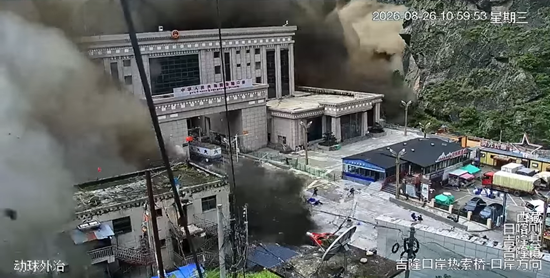
This was not a conventional monsoon flood caused simply by prolonged rainfall. Early scientific assessments indicate that it was a multi-stage mountain disaster: a high-altitude slope failure sent a huge mass of glacial ice and bedrock into a river valley, temporarily blocking the flow before the natural barrier failed. The resulting wall of water, mud and boulders travelled downstream with devastating force.
What triggered the Nepal flash floods?
Scientists are still examining satellite images, seismic records and field evidence, so the precise sequence should not be treated as final. The most widely accepted initial explanation points to a major collapse on the northern slopes of Langtang Lirung, close to the Nepal–Tibet border.
A large section of glacier and underlying rock appears to have broken away at an elevation of about 5,200 metres. The material fell roughly 1,200 metres into the valley, creating an immense ice-and-rock avalanche. The collapse released so much energy that instruments recorded a seismic signal equivalent to a magnitude 5.2 event. It was initially mistaken for an earthquake, but subsequent analysis indicated that the collapsing mountain mass itself produced the signal.
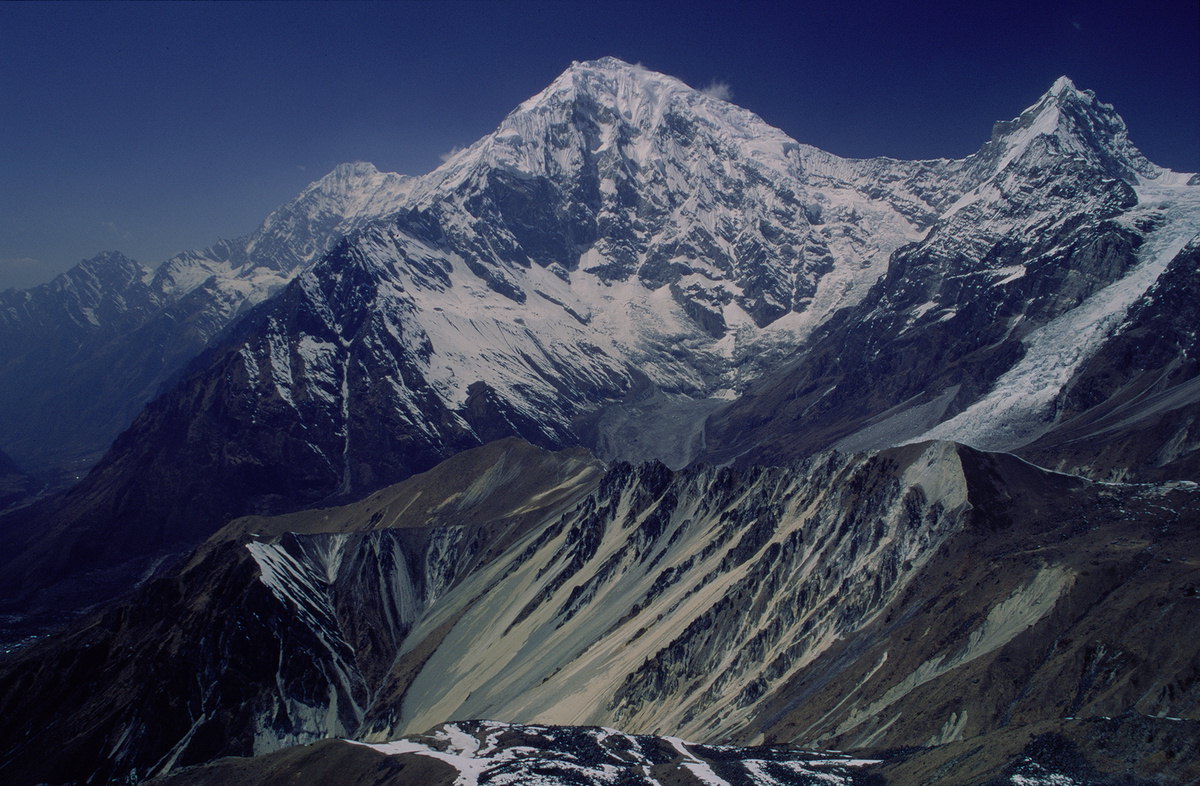
The avalanche entered the Lhende Khola river system and carried ice, rock, soil and sediment through a confined valley. Debris is believed to have obstructed the river temporarily, forming a natural dam and allowing water to accumulate behind it. When the unstable barrier gave way, the stored water combined with mud and boulders to produce a high-speed flood.
Estimates cited by experts suggest that the debris flow may have travelled at around 50 metres per second—about 180 kilometres per hour—in its initial stages. In such conditions, communities close to the source would have had only minutes, or perhaps no meaningful warning at all, before the surge arrived.
Why the Nepal flash floods cascaded across borders
The disaster demonstrates why Himalayan emergencies cannot always be understood as single events. The initial slope failure set off a chain reaction: glacier and rock collapse, avalanche, river blockage, sudden dam failure, debris flow and downstream flash flooding. Each stage intensified the next.
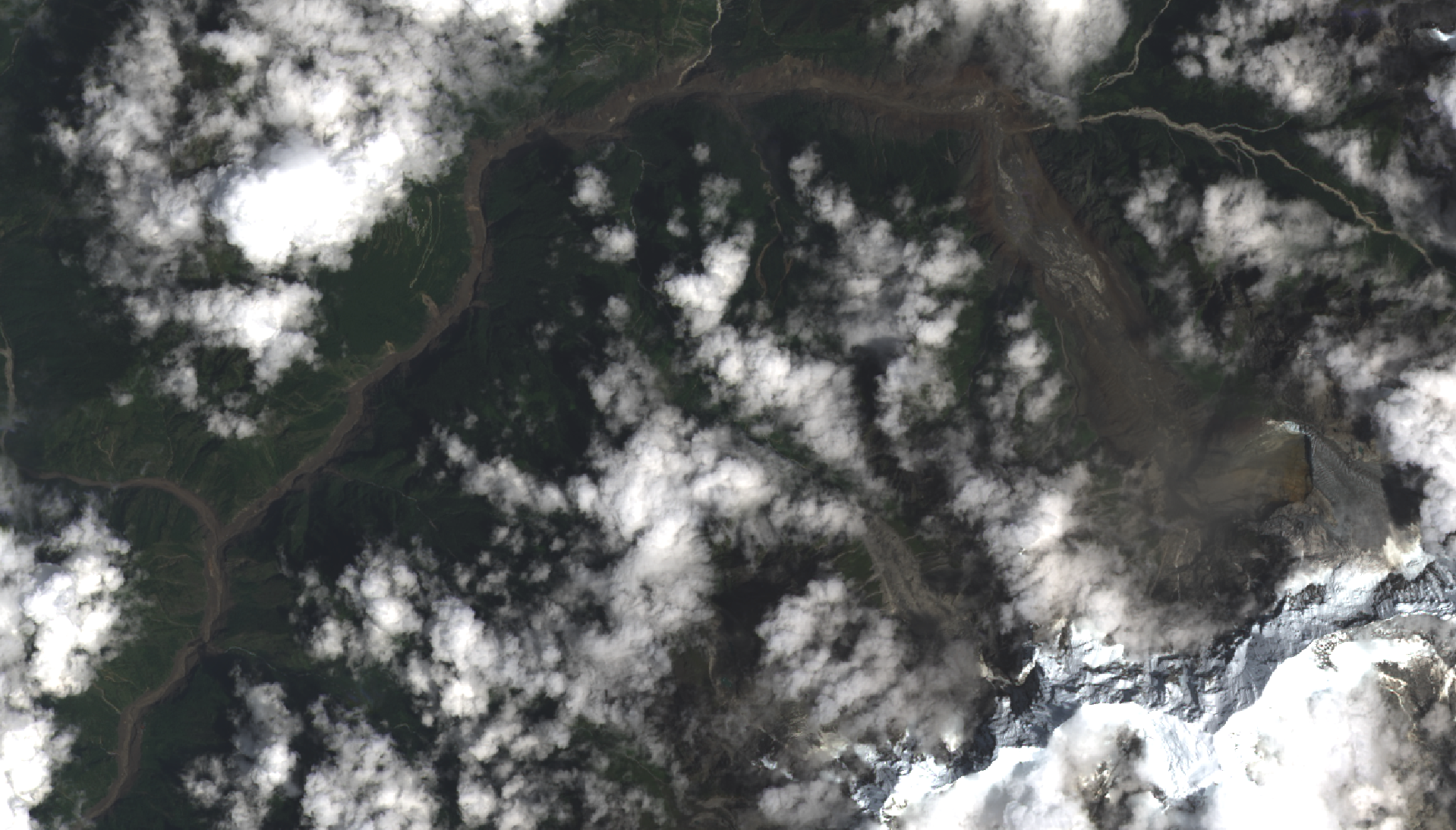
The flood moved through a transboundary river system linking Tibet and Nepal. It damaged the Gyirong border area and sent destructive flows towards Nepal’s Rasuwa district and downstream settlements. Homes, roads, bridges, border infrastructure and power projects were caught in the path. The loss of roads and communications then created another layer of risk by delaying rescue teams, restricting the movement of relief supplies and isolating survivors.
Hydropower losses are particularly serious. Damaged projects reportedly account for more than 12 per cent of Nepal’s energy capacity. This means that the disaster is not only a humanitarian emergency but also an energy, economic and development crisis. Power shortages, interrupted trade and the cost of rebuilding may affect the country long after the immediate rescue phase ends.
Why the Himalayas are becoming more unstable
It is too early to attribute this individual collapse to one cause. High mountain failures can result from several interacting factors, including the structure of the rock, glacier movement, steep terrain, erosion, accumulated meltwater and the thawing of frozen ground. However, the wider pattern of warming across the Hindu Kush Himalaya is an important part of the risk picture.
Rising temperatures accelerate the loss of glacier ice and can alter the physical support that ice provides to mountain slopes. Thawing permafrost—the permanently frozen material that helps bind rock together—may further weaken steep faces. Meltwater can enter fractures, increase pressure and reduce stability. These processes do not guarantee that a collapse will occur at a particular place or time, but they can create conditions in which large failures become more likely.
The Himalayan region is often described as the “water tower of Asia” because its snowfields and glaciers feed major rivers used by hundreds of millions of people. Changes in the cryosphere therefore have consequences far beyond mountain communities. Glacial lake outburst floods, ice avalanches, landslides and debris flows can travel rapidly into settled valleys and damage infrastructure built many kilometres downstream.
Why conventional warning systems did not help
Flood forecasting has traditionally focused on rainfall, river levels and seasonal monsoon patterns. Those systems remain essential, but they may not provide sufficient warning for a sudden glacier or slope collapse. A disaster beginning above 5,000 metres can develop far faster than an ordinary river flood, leaving little time for official messages to reach the people most exposed.
The Nepal tragedy underlines the need for a multi-hazard early-warning system that combines satellite observation, seismic detection, automatic river gauges, ground movement sensors, weather information and local communication networks. Seismic instruments may detect the energy released by a major collapse. River sensors can identify an abnormal rise or sudden blockage. Satellite radar can help monitor changes in glaciers, unstable slopes and moraine dams even when clouds obscure the mountains.
Technology, however, is only one part of an effective warning chain. An alert is useful only if it reaches the right people quickly, is understood and leads to a practised response. Remote settlements, construction camps, hydropower sites, tourist routes and border facilities need clearly marked evacuation paths, safe assembly areas, reliable sirens and trained local volunteers. Messages should be available in local languages and transmitted through several channels, including radio, mobile networks, satellite communication and community messengers.
Risk-sensitive infrastructure is now essential
Nepal’s development needs are substantial, and hydropower, roads, bridges and border trade are central to its future. Yet major infrastructure in Himalayan valleys must be planned for compound and cascading hazards rather than historical flood levels alone.
Risk assessment should examine the entire upstream catchment, including glaciers, glacial lakes, unstable rock faces, landslide zones and places where debris could block a river. Critical facilities should not be concentrated in narrow channels without safe redundancy. Bridges and access roads need designs that account for heavy sediment, boulder impact and the possibility of sudden channel shifts. Hydropower projects require emergency action plans, independent communication systems and evacuation protocols for workers and nearby communities.
Land-use planning is equally important. Hazard maps should guide where new homes, public buildings, markets and tourism facilities are permitted. Where existing settlements cannot be relocated, authorities should identify shelters, strengthen protective works where feasible and ensure that communities know how to respond to an alert.
Regional cooperation must move from discussion to operation
This disaster crossed an international border within minutes. Rivers, glaciers and debris flows do not follow administrative boundaries, making cooperation between Nepal, China and downstream countries indispensable.
Countries in the region should establish real-time protocols for sharing satellite observations, river data, seismic alerts and information about newly formed barrier lakes. Joint scientific teams can assess unstable slopes and glacial hazards, while coordinated emergency procedures can speed up rescue operations and the movement of specialist equipment. Shared exercises would help border agencies, hydropower operators and local authorities understand who issues an alert, who receives it and what happens next.
International support will also be needed for reconstruction. However, rebuilding should not simply restore the same exposure. Recovery funding must be linked to updated hazard assessments, safer sites, stronger construction standards and more resilient transport and energy networks.
Putting communities at the centre of preparedness
People living in high-risk valleys are not merely victims; they are the first observers and often the first responders. Their knowledge of unusual river sounds, changes in water colour, falling water levels, slope movement and past flood routes can complement scientific monitoring.
Community-based disaster management should therefore be a core part of Himalayan resilience. Villages need local risk maps, household evacuation plans, first-aid training, emergency supplies and regular drills. Schools, hotels, trekking operators, transport unions and religious-tourism groups should be included because visitors may not understand local hazards or evacuation routes.
Special attention is required for children, older people, persons with disabilities, migrant workers and tourists. Preparedness plans must identify who may need assistance, who will provide it and how families separated during an evacuation can be reunited.
A warning from the high mountains
The Nepal flash floods are a painful reminder that disasters in a warming Himalayan region can emerge through unfamiliar and rapidly evolving chains of events. The lesson is not that every glacier will collapse, but that countries can no longer rely only on past experience when assessing future risk.
The immediate priority is to rescue survivors, support bereaved families, restore essential services and provide safe shelter. The longer-term responsibility is to learn from the event. Better monitoring, cross-border data sharing, risk-sensitive infrastructure and community preparedness can reduce losses, even when a hazard cannot be prevented.
Nepal’s tragedy should become a turning point for the entire Himalayan region. Scientific knowledge must be converted into practical warning systems, development decisions must reflect mountain risk and local communities must be empowered to act. In a landscape where ice, rock, water and people are closely connected, resilience depends on understanding the full chain before the next disaster begins.
Sources: Reuters reporting dated 27–29 August 2026; International Centre for Integrated Mountain Development (ICIMOD); US Geological Survey assessments; and contemporary reporting by Channel News Asia and The Guardian.